Mine Site Ecological Index

Achieve a baseline state for mine restorations

Comprehensive

vegetation change monitoring in a single index

Scalable

performance tracking across multiple mine sites

Historical

twenty three years of accessible data for robust baselining of new sites

Mine restoration and rehabilitation

Monitor ecological succession at any mine site

Reduce environmental monitoring costs for mine restoration using remote sensing with the Descartes Labs Mine Site Ecological Index. Using this index, a Mine Site Restoration Manager or Sustainability Officer can track the restoration performance of individual mines or many mines at a distance. This information can also be used to inform key stakeholders, such as regulatory agencies, when applying for new mine permits as a demonstration of past restoration performance.

The Mine Site Ecological Index is a combination of ecological indicators and derived measurements we've identified and collected from various earth observation systems that record the mine site over time. By applying the index to both the restoration site and the baseline site for comparison, Mine Restoration Managers can measure how close the restoration is to achieving a “pristine state”, defined as the baseline state.

Changes in biomass over a mine site from 2007–2019.

Who we serve

Progress towards sustainability, KPIs, and meeting stakeholder expectations

Providing value for Mine Sustainability Officers, Government Mine Permitting Officers, and Mine Equity Ratings Analysts.

Mining Sustainability Officer

The index can identify problematic areas within the restoration project and allow Mining Sustainability Officers to focus their on-site visits more accordingly, thereby potentially saving thousands of dollars in on-site time reduction. Record of the Mine Site Ecological Index data for existing mines can also be used as evidence of positive past performance when applying for new mine site  approval.

Government Mine Permitting Officer

Governmental officials can monitor many mines over a broad area to ensure that critical milestones are being met for existing mines under their purview. This service can extend the reach of governmental oversight by reducing spending from travel costs. Historical data can also be used to assess specific operators that are underperforming and allows permitting officers to include mitigations within the permitting plan.

Mine Equity Ratings Analyst

Equity ratings agencies and firms can differentiate themselves by providing insights on the natural capital risk caused by assets owned by the firms they rate. Both scalable and cost-effective, our tools work in conjunction with a corporation's existing ratings packages to allow the creation of differentiated mining company natural capital ratings.

Highlights

Facilitating the recovery of ecological environments

Fuse the world’s best data and analytics to monitor mine closure and rehabilitation and meet the expectations of key stakeholders.

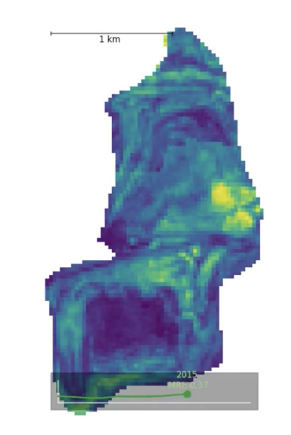
Rapid assessment of mine sites

Quickly assess whether a mine site is trending toward restoration utilizing a single index as opposed to analyzing a multitude of environmental variables manually.

Track restoration performance

The underlying drivers behind restoration performance can be investigated by accessing model inputs and their trends over time.

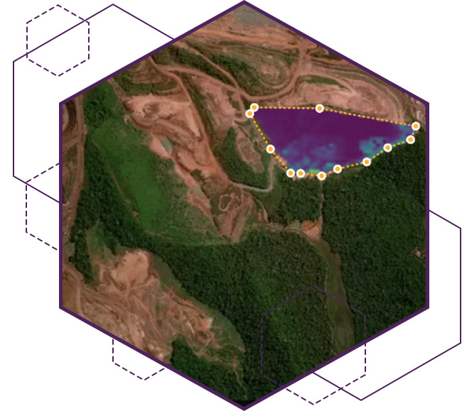
Baseline location flexibility

Users have the flexibility to select whatever baseline location they would like to measure performance against near the mine site.

Globally scalable analysis

The Mine Site Ecological Index can be run for nearly any location globally provide a comprehensive KPI across the mining operations portfolio.

Analysis of mine site using the Descartes Labs Mine Site Restoration Index.

Product features

The Descartes Labs Mine Site Ecological Index gives users access to a blend of data sets which provide them with the ultimate goal of mine site restoration progress in the form of an index, as well as the underlying inputs to the model.

Mine Site Ecological Index Time Series

Mine Site Ecological Index users can select a time range and a location to generate a historical record of the index compared to a baseline location. This data can be used in plotting tools to demonstrate mine progress towards restoration.

Mine Site Ecological Index Raster Data

Visualized progress across the mine site spatially can be downloaded as a raster data set for each year. This data can then be plotted in mapping tools to see how the restoration activity is performing across different portions of the mine for each year.

Mine Site Ecological Index Model Inputs

To assess what is driving the index performance, good or bad, users can see the time series data associated with the various inputs that the model utilizes for each site. This information can then drive prescriptive action in certain locations to improve restoration performance.

Product specs

Easy-to-use API with location-customization

Data Range

The Mine Site Ecological Index can access historical data dating back to the year 2000.

Product Delivery

The service is currently offered as a REST API interface which requires a date range and properly formatted polygons for the mine site and the baseline location.

Data Frequency

The underlying input data can be generated on a biannual basis for select inputs but the model itself updates on an annual cadence.

Visualization

Available via the Descartes Labs Explorer web application, the data output is in the form of a time series over the polygon, or a raster file for each polygon by year.

Geographical Availability

The model is generated on a mine site basis and so is created for each mine site upon client request and is generally available on a global basis.

Improve safety with automated, global
infrastructure risk monitoring.

Talk to an expert to learn how Descartes Labs can grow your business.